From Vision to Plan: Roadblocks...literally
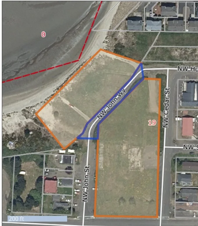
John Way
When we first sat down with our early sketches and a head full of ideas, we thought: how hard could this really be? We had a vision that felt grounded and playful, the land was in hand, and we’d even gotten encouraging initial feedback from folks in town. It felt like things were lining up.
Then came our first real roadblock. Literally.
At a glance, our parcel looked like a single, continuous piece of land—just as it had been when Waldport’s middle school sat here, complete with a baseball field that ran all the way down toward Alsea Bay. But as we got deeper into the planning process, we learned that wasn’t quite the case anymore.
A remnant of a failed 2000s subdivision called Dream Harbor still lived on the property. Years before, developers had installed a road and underground utilities before the financial crash of 2008 halted the project entirely. The road—called John Way—was technically now a public right of way, bisecting our land nearly in half. Which meant: a public road ran directly through what we hoped would become a peaceful, car-free resort. Not ideal.
Designing a family-friendly resort—with open-air gathering spaces, picnic lawns, and a putting course—on a split parcel with vehicle traffic running through the middle? We couldn’t make that work, no matter how many sketches we attempted. It wasn’t just an inconvenience; it was a dealbreaker.
That’s when we first learned about the process of vacating a public right of way. We’d never heard of it before. And when we brought it up to the city planner, the response was… cautious. He said we could try, but that vacating public rights of way in Oregon was nearly as hard as altering water rights—known for being legally tricky and rarely granted.
Still, we believed in the vision—and we couldn’t see a future for Treasure Bay that didn’t treat this land as one continuous, shared space. So we rolled up our sleeves.
We submitted an official application to vacate John Way, and began the work of preparing a presentation to the City Council. We argued that the road, in its current form, no longer served a public need, and that our plans for the land would restore its legacy as a place for gathering, play, and community. We emphasized safety, especially for kids and pedestrians, and proposed that the city retain a utility easement under the road so that infrastructure would still be accessible—while returning the surface rights to us.
When it came time to stand in front of the Council, we were nervous. This wasn’t just paperwork—it was the very foundation of our project.
And then, a moment of relief: a unanimous vote in our favor. The city granted our request. The land once held by John Way would be returned to us. It was a huge victory—one that allowed our vision to stay intact.
But it was just the first of many hurdles ahead.
With the road issue resolved, we could finally start to reimagine the layout. That meant returning to the Planning Commission with a new proposal, this time focused on what would go in the newly unified space—an 18-hole putting course designed for all ages and abilities.
That, of course, is a whole story of its own… and one we’ll get into in the next entry of The Treasure Log.